

The Global Monitoring for Environment and Security in Africa (GMES) is implementing a Land Degradation Monitoring and Assessment (LDMA) application within the Greater Horn of Africa and the West Indian Ocean Islands. The LDMA application is a continuing service initiated and developed during AMESD and MESA respectively. The previous phases involved service development and operationalization of the service. Products generated in this service include regional and national land degradation index maps and land degradation hotspots maps to inform policy makers on localized areas of intervention within their respective countries.
Between February 21 and March 2 2021, the RCMRD- GMES & Africa team carried out a monitoring and assessment of the land degradation validaion in Sudan. In this regard, the Sudan land degradation map was prepared by team as shown in the figure below and field validation on the product generated was also conducted.
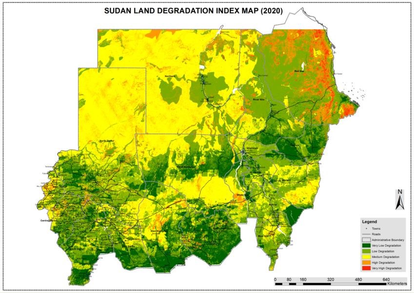
Figure 1: Sudan Land Degradation map
The sample sites for field verification were selected based on the various levels of degradation as depicted on the model and being representative of the East and South eastern region depending on accessibility and security concerns. The states visited were Kassala, Al Qadarif, Sennar and Blue Nile. Before heading out to the various field sites, consultations were held with the various government agencies in each state on the objective of the mission, GMES project goal and how this data would inform decision making at various levels.
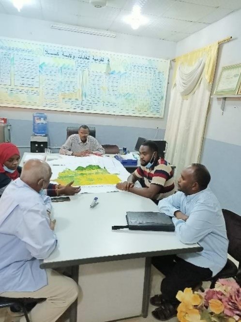
Figure 2: consultation meeting with Director of Council of Environment and Natural Resources, Kassala State
Ground truthing in Kassala revealed that anthropogenic factors the main drivers of degradation. The increase in both human and livestock population has put pressure on the resources available thus leading to unsustainable extraction of the resources. Over time, the land has been left bare thus further exposing the land to wind erosion, this is quite evident in Aklah where strong wind currents play a key factor in aggravating the erosion levels. In Hangola, the cutting down of indigenous trees has exposed the land to strong winds which carry lots of sand thus leading to sand dunes, the sand dunes have over the past decade been encroaching on wetlands thus further reducing the ecosystem services and goods derived from the wetland. In Tambai Alabar, deep gullies have been formed due to water erosion, this has in turn affected the little arable land available.
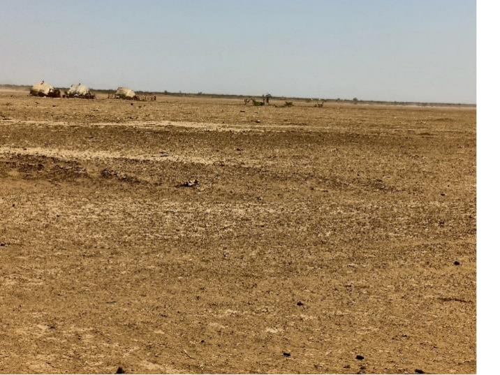
Figure 3: Aklah, a site highly prone to wind erosion
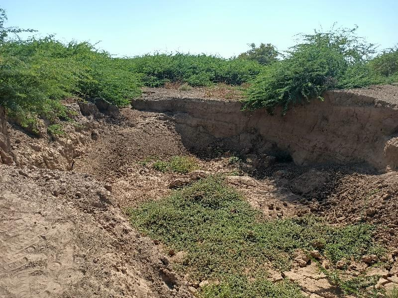
Figure 4: Sand dunes in Hangola forming due to high rate of wind erosion encroaching on a wetland.
In Al Qadarif, the drivers for degradation are anthropogenic factors, this has been exacerbated by minimal ground cover and thus soil erosion levels are really high. In Kutota Valley, a whole village was engulfed with deep gullies that made them vulnerable to flash floods and affected their overall safety. The village had to be relocated about 3Km away, however in the past few years the gullies have continued to expand and progress and are just about a few meters to catch up and engulf the site where the village was relocated to.
In Abofarah valley, there have been efforts to slow down and minimize the effects of soil erosion. The community, with the support of local administration have embarked on tree planting within the major gullies so as to slow down the kinetic energy of the run-off water, thus reducing the soil erosion. Moreover, the trees are helping in holding the soil structure together and in water percolation. Further, several water pans (hafir) have been constructed to tap and store the excess run-off thus supporting the agro-pastoral livelihood within the locality.
Figure 4: (Moving clockwise) Top left, Deep gullies in Kutota valley as a result of soil erosion; Top right, a village in Kutota valley that had previously been re-located after being ravaged by gullies, is now being engulfed by the same; Bottom right, tree planting in deep gullies within Abofarah valley to slow down water run-off and minimize erosion; Bottom left Water pans constructed within Abofarah valley to hold excess run-off.
Agricultural activities coupled with deforestation contribute highly to soil erosion in Sennar state. This can be observed across various villages in Sennar such as Erdeeba, Nooraniah and Shawa Armana. This has in turn reduced agricultural productivity as most lands are being wasted away. Moreover, due to excess run-off in Shawa Armana, water has settled in lower parts of the village and thus engulfed previous farmlands.
Figure 5: (Moving clockwise) Top left, Gullies in Erdeeba famlands; Top right and Bottom right, both sheet and reel erosion in farmlands in Nooraniah; Bottom left, Excessive water run-off in the last two rainy seasons has resulted in water settling in the lower parts of Shawa Armana village thus submerging farmlands.
Mining activities and deforestation contribute highly to soil erosion in Blue Nile state. Open excavation mines continue to aggravate the rate of soil erosion and so is deforestation. Due to the high population in the villages around Dindir national park, extraction of biomass for purposes of domestic n commercial use is quite high.
Figure 6: Left, Gullies forming in villages around Dindir national park as a result of anthropogenic activities; Right, abandoned open mines continue to aggravate soil erosion in parts of Blue Nile state.
In conclusion, anthropogenic factors were found to be the main driver of soil erosion in Sudan. In the states of Kassala and some parts of Sennar, apart from water, wind contributes significantly to soil erosion.
Challenges:
Before conducting field work in Sudan; one requires clearance and a permit from the Ministry of Interior (Homeland security). This takes between a day to two, and can only take place once you have arrived in Sudan, thus it should be factored when setting out the number of days for field work.
Moreover, one can only visit places (towns) mentioned in the permit. Straying 5km-10km from that particular town listed in the permit attracts penalty from the police. This is quite a huge limiting factor, since land degradation phenomena can spread over wide areas within one’s investigation area.
Average car hire costs in Sudan were well above the provision of the GMES & Africa budget. Therefore, this should be looked at in consequent field works.