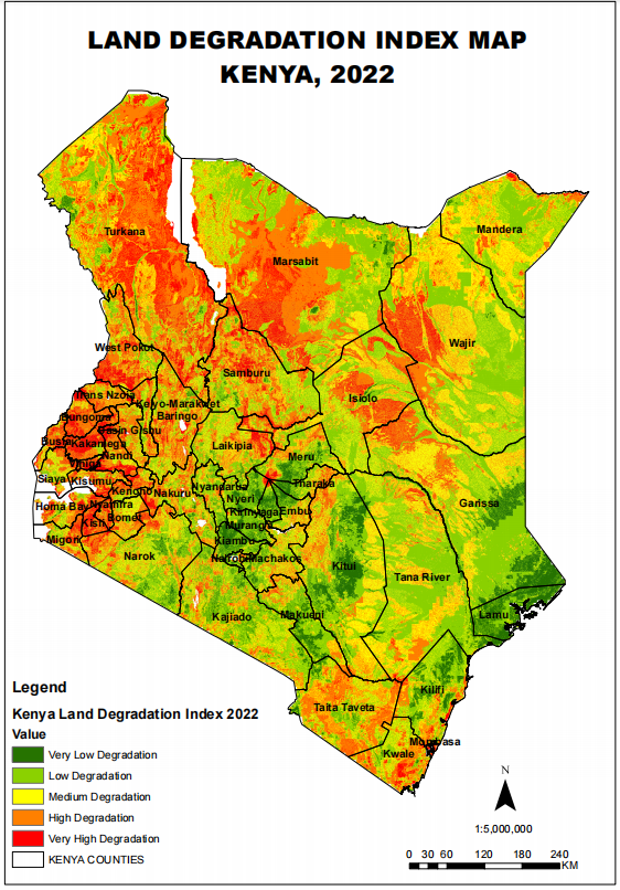
The success of any large-scale environmental initiative hinges on accurate data and insights. Under the Global Monitoring and Environment and Security and Africa (GMES and Africa) project, RCMRD has supported Directorate of Resource Surveys & Remote Sensing (DRSRS), with Land Degradation Index Maps(LDIM) which will be used in tree planting initiative launched by His Excellency the President.
As a contribution towards this initiative, Directorate of Resource Surveys & Remote Sensing (DRSRS), has developed a JAZAMITI Application. This geoportal application is set to transform the way Kenya monitors and manages its nationwide tree planting efforts.
According to the Vincent Imala, Geo-Information Officer at DRSRS, this dataset will be instrumental in guiding the Kenyan government's strategic decisions regarding priority areas for tree planting across the 47 counties. ‘By analyzing the LDIM data, we aim to identify highly degraded areas for intervention ensuring the maximum ecological and societal impact’
The Directorate of Resource Survey and Remote Sensing (DRSRS) is a government agency in Kenya that plays a crucial role in the management and utilization of geospatial information and remote sensing data for various purposes, including natural resource management, environmental monitoring, and development planning. Under GMES and Africa Project, DRSRS is a key implementing partner in Kenya.
.